The Earth Cloud Aerosol and Radiation Explorer (EarthCARE) satellite, a joint venture between the European Space Agency (ESA) and the Japan Aerospace Exploration Agency (JAXA), launched on 29 May 2023 from the Vandenberg Space Force Base in California, USA, on a SpaceX Falcon 9 rocket.
This ambitious mission aims to revolutionise our understanding of the complex interactions between clouds, aerosols and radiation in Earth’s atmosphere and their impact on the global climate system.
EarthCARE Launch and Orbit
EarthCARE, the largest and most complex Earth Explorer mission developed by ESA to date, successfully launched on 29 May 2023 at 22:20 GMT (28 May, 15:20 local time) from the Vandenberg Space Force Base in California, USA. The satellite began its journey into space aboard a SpaceX Falcon 9 rocket.

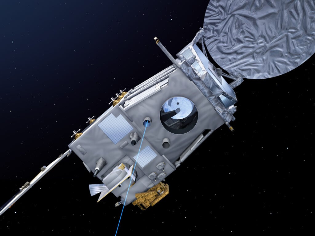
Ten minutes after liftoff, EarthCARE separated from the Falcon 9 rocket’s upper stage, followed by the successful deployment of its solar panel and the Cloud Profiling Radar (CPR) antenna. At 01:14 CEST, the Hartebeesthoek ground station in South Africa received the first signal from the satellite, confirming its safe arrival in orbit.
EarthCARE now orbits Earth at a mean altitude of approximately 393 km in a sun-synchronous orbit with an inclination of 97.05°. This specific orbital configuration ensures global coverage and consistent observation times, with the satellite crossing the equator in the early afternoon (14:00 local time) on the descending node. The orbit has a repeat cycle of 25 days, consisting of 389 orbits, and an orbital period of 92.5 minutes.
The mission will progress through several phases, starting with the Launch and Early Orbit Phase (LEOP), during which the satellite’s essential functions and health will be verified. The subsequent Commissioning Phase, expected to last six months, will focus on the functional checks and calibration of the satellite’s platform and scientific instruments and validating data processing algorithms and product quality.
After completing the commissioning phase, EarthCARE will enter its operational phase, planned to last a minimum of 2.5 years and with sufficient consumables for an additional year of operations. During this phase, the satellite will continuously acquire scientific data to be processed, distributed, and publicly available to the global user community.
The EarthCARE Ground Segment, consisting of the ESA and JAXA operations and data processing facilities, will be crucial to the mission’s success. ESA’s Flight Operations Segment (FOS) in Darmstadt, Germany, will be responsible for satellite control, health monitoring, and orbit maintenance. At the same time, the Payload Data Ground Segment (PDGS) at ESA-ESRIN in Frascati, Italy, will handle science data acquisition, processing, archiving, and distribution.
The Ground Segment has been designed to minimise data latency to maximise the scientific impact and operational use of EarthCARE data. All the crafts Level 1 and Level 2 data products will be made available to users within 24 and 48 hours of acquisition, respectively, with any contingency cases recovered within five days.
This rapid data delivery allows for the fast distillation of EarthCARE observations into weather prediction models and supports near-real-time monitoring of the satellite’s performance and data quality. It will also enable the scientific community to swiftly use the data for research purposes and the development of downstream applications.
What is EarthCAREs aim?
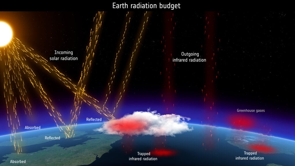
Clouds and aerosols play a crucial role in regulating Earth’s energy balance, but their precise effects remain one of climate science’s most significant sources of uncertainty. Clouds can reflect incoming solar radiation into space, cooling the planet and trap outgoing infrared radiation, warming it. The net effect depends on cloud height, thickness and microphysical properties, which must be adequately represented in current climate models.

Aerosols, tiny suspended particles in the atmosphere, also influence the climate directly by absorbing and scattering radiation and indirectly by acting as cloud condensation nuclei. Changes in aerosol concentrations due to human activities can significantly alter regional cloud properties and precipitation patterns.
EarthCARE will provide global observations of cloud and aerosol vertical profiles and collocated solar and thermal radiation measurements to address these knowledge gaps.
What are vertical profiles? The satellite will use special tools to measure clouds and aerosols at different atmospheric heights, from the ground up to space. This will give scientists a 3D picture of their location.
What are collocated measurements? At the same time and in the same place that EarthCARE measures the clouds and aerosols, it will also measure the amount of sunlight (solar radiation) and heat (thermal radiation) present.
Putting it together: By collecting all this information simultaneously and in place, scientists can better understand how clouds and aerosols interact with sunlight and heat. This will help them determine whether clouds and aerosols make Earth warmer or cooler in different locations and situations.
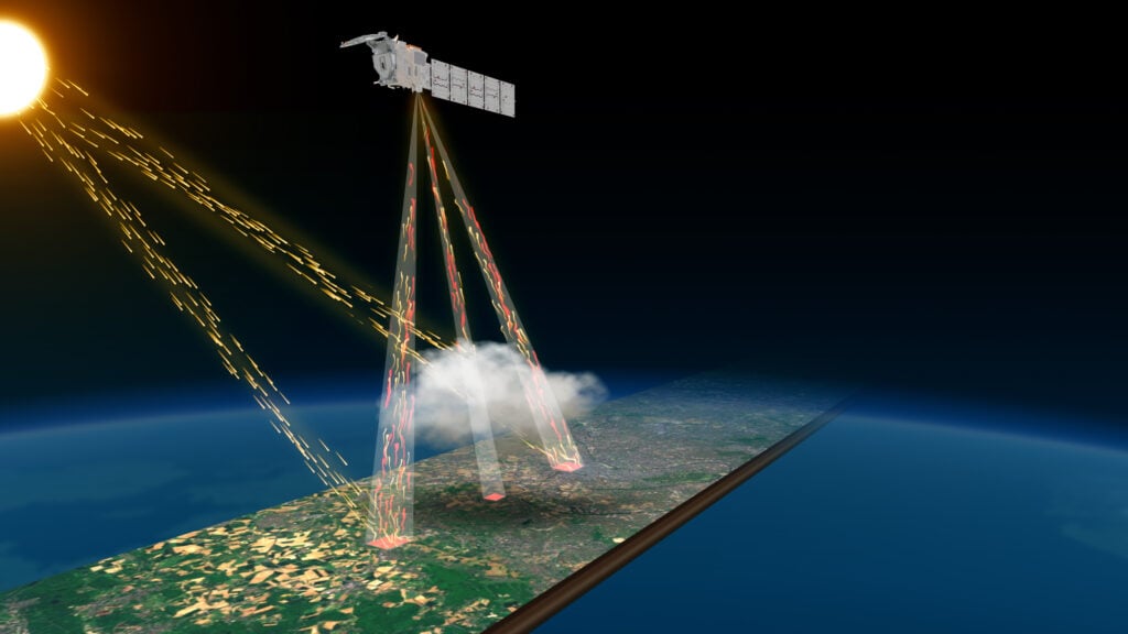
The satellite carries a suite of four state-of-the-art instruments, the ATmospheric LIDar (ATLID), Cloud Profiling Radar (CPR), Multi-Spectral Imager (MSI) and Broadband Radiometer (BBR), working in synergy to capture a comprehensive picture of the atmosphere.
By combining active sensors (ATLID and CPR) that can penetrate through clouds with passive sensors (MSI and BBR) that measure radiances across a wide spectral range, EarthCARE will provide unprecedented insights into the vertical distribution of clouds and aerosols, their microphysical and radiative properties, and their interactions with each other and the Earth’s energy budget.

The data collected by EarthCARE will be used to evaluate and improve the representation of clouds, aerosols and radiation in numerical weather prediction and climate models. More accurate simulations of these processes will enhance our ability to predict future climate change and its regional impacts, informing policy decisions on mitigation and adaptation strategies.
Beyond its scientific objectives, EarthCARE demonstrates the power of international collaboration in advancing our understanding of the Earth system. The mission builds upon the success of previous joint ventures, such as the CloudSat and CALIPSO missions. It showcases the technical capabilities and expertise of ESA, JAXA and their industrial partners.
As the impacts of climate change become increasingly evident, from more frequent extreme weather events to rising sea levels, the need for accurate and reliable climate predictions has never been greater. EarthCARE represents a significant step forward in our ability to observe and model the complex processes that shape our planet’s climate, paving the way for more informed decisions to safeguard our future.
Earthcare Scientific Objectives and Background
EarthCARE’s primary scientific objective is to advance our understanding of clouds and aerosols’ role in Earth’s radiation budget and climate system. The mission aims to address critical uncertainties in quantifying global cloud and aerosol distribution, their microphysical and radiative properties, their interactions, and the Earth’s energy balance.
Clouds significantly influence Earth’s climate through their ability to reflect incoming solar radiation (cooling effect) and trap outgoing infrared radiation (warming effect).
Clouds play a crucial role in regulating the Earth’s temperature through a process known as the radiative effect. This effect occurs because clouds can absorb and reflect incoming solar radiation from the sun and trap outgoing infrared radiation emitted by the Earth’s surface. During the day, clouds reflect a portion of the incoming sunlight into space, cooling the Earth’s surface. At night, however, clouds act as an insulating blanket, trapping the infrared radiation emitted by the Earth, thereby preventing it from escaping into space and leading to a warming effect. The overall impact of clouds on the Earth’s temperature depends on various factors, such as their altitude, thickness, and composition.
The net radiative effect of clouds depends on their altitude, thickness, horizontal extent, and microphysical properties such as droplet size and ice crystal shape. However, the representation of these cloud properties and their feedback in current climate models is limited, leading to significant uncertainties in predicting future climate change.

Aerosols, suspended particles in the atmosphere from natural and anthropogenic sources, also play a complex role in the climate system. Depending on their size, composition, and optical properties, aerosols can directly influence the Earth’s radiation balance by scattering and absorbing solar and thermal radiation. Additionally, aerosols act as cloud condensation nuclei (CCN) and ice nuclei (IN), indirectly affecting cloud formation, lifetime, and precipitation efficiency.
The interactions between aerosols and clouds, known as aerosol-cloud interactions, represent one of climate projections’ most significant sources of uncertainty. Changes in aerosol concentrations due to human activities, such as industrial emissions and land-use changes, can alter cloud properties and precipitation patterns on regional to global scales. Quantifying these effects is crucial for understanding the anthropogenic influence on climate and the potential consequences of future changes in aerosol emissions.
Despite significant progress in observing and modelling clouds and aerosols, current satellite missions and ground-based observations have limitations in providing the necessary vertical profiles and coincident measurements of cloud, aerosol, and radiation properties. Passive sensors, such as imaging radiometers, provide valuable information on cloud and aerosol horizontal distribution but cannot resolve their vertical structure. Active sensors like radar and lidar can profile clouds and aerosols but have limited spatial coverage and sensitivity.
EarthCARE addresses these observational gaps by combining advanced active and passive remote sensing techniques. The satellite’s lidar (ATLID) and radar (CPR) instruments will provide unprecedented vertical profiles of cloud and aerosol properties with high sensitivity and resolution. The lidar’s high-spectral-resolution capability enables the discrimination of aerosol types and the determination of their optical properties. The radar’s Doppler capability allows for measuring cloud vertical motion and retrieving precipitation rates.
Alongside these active sensors, EarthCARE’s multi-spectral imager (MSI) will provide contextual information on the cloud and aerosol horizontal distribution across a 150-km swath. The broadband radiometer (BBR) will measure the top-of-atmosphere radiances and fluxes in the solar and thermal infrared ranges, enabling the evaluation of the radiative effects of the observed cloud and aerosol scenes.
Using these instruments will enable EarthCARE to provide a comprehensive dataset of cloud and aerosol properties, along with their radiative impact, on a global scale, develop and evaluate advanced retrieval algorithms, improve cloud and aerosol parameterisations in climate and numerical weather prediction models, and reduce uncertainties in climate change projections.
Earthcare Instrument Payload and Measurement Capabilities
EarthCARE’s ambitious scientific objectives are made possible by its advanced instrument payload, consisting of four state-of-the-art sensors: ATLID, CPR, MSI, and BBR. Each instrument contributes unique measurements that, when combined, provide a comprehensive understanding of clouds, aerosols, and their radiative effects.

ATLID: Atmospheric Lidar
- ATLID is a high-spectral-resolution lidar operating at a wavelength of 355 nm.
- It emits short laser pulses into the atmosphere and measures the backscattered light to determine aerosols’ and thin clouds’ vertical distribution and optical properties.
- ATLID’s high-spectral-resolution capability allows it to distinguish between molecular (air) and particulate (aerosol and cloud) backscatter, providing detailed information on aerosol types and their optical depths.
- The instrument also features a depolarisation channel, which helps identify non-spherical particles such as ice crystals and dust.
CPR: Cloud Profiling Radar
- CPR is a 94 GHz (W-band) Doppler radar that probes the vertical structure of clouds and precipitation.
- It transmits microwave pulses and measures the backscattered signal to determine clouds’ location, thickness, and internal structure, including ice, liquid water, and precipitation.
- CPR’s high sensitivity allows it to detect even thin ice clouds that are difficult to observe with passive sensors.
- The Doppler capability enables CPR to measure the vertical motion of cloud particles, providing insights into cloud dynamics and precipitation processes.
MSI: Multi-Spectral Imager
- MSI is a passive imaging radiometer that observes the Earth’s surface and atmosphere in seven spectral bands, ranging from visible to thermal infrared wavelengths.
- It provides contextual information on the horizontal distribution of clouds and aerosols across a 150-km swath, complementing the vertical profiles from ATLID and CPR.
- MSI’s multi-spectral measurements enable the retrieval of cloud properties such as optical thickness, particle size, and phase (liquid or ice).
- The imager’s data is also used to derive surface properties, such as vegetation cover and surface temperature, essential for understanding the Earth’s energy balance.
BBR: Broadband Radiometer
- BBR measures the top-of-atmosphere radiances and fluxes in three broad spectral ranges: total (0.25-50 μm), shortwave (0.25-4 μm), and longwave (4-50 μm).
- It has three fixed telescopes pointing in different directions (forward, nadir, and backwards) to sample the angular distribution of the reflected solar and emitted thermal radiation.
- BBR’s measurements determine the Earth’s radiation budget and validate the radiative transfer calculations based on the cloud and aerosol properties retrieved from the other instruments.
The real power of EarthCARE lies in the combination of these instruments. By combining the data from ATLID and CPR with the information from MSI and the measurements of the amount of incoming and outgoing radiation in the Earth’s atmosphere recorded by the BBR, scientists can construct three-dimensional scenes of clouds and aerosols and their radiative effects.
Data Products and Applications
EarthCARE’s cutting-edge instruments will generate a wealth of data to help scientists better understand how clouds and aerosols impact our climate. The mission’s data will be processed into different levels, each providing unique insights into the atmosphere.

Level 1 data products can thought of as raw materials containing measurements directly from the satellite’s instruments. These include information on the amount of light scattered back from clouds and aerosols (ATLID and CPR), the brightness of the Earth in different colours (MSI), and the total amount of energy coming from the Earth (BBR).
Level 2 data products are like finished products, created by combining and processing the Level 1 data using complex mathematical models. These higher-level products provide more detailed information about clouds and aerosols, such as:
- The types of clouds (liquid water or ice) and their heights and thicknesses
- The amount of water or ice in the clouds
- The types of aerosols, how much light they absorb or scatter, and their vertical distribution
- The rates of rainfall and snowfall
- The amount of energy absorbed, reflected, or emitted by the Earth and atmosphere
To ensure the accuracy of these data products, the EarthCARE science team has developed sophisticated methods to process the data and validate the results using independent measurements from other satellites, ground-based instruments, and aircraft campaigns.
The data from EarthCARE will be used to improve weather and climate models, which are like computer simulations of the Earth’s atmosphere. By providing detailed information on clouds and aerosols, EarthCARE will help make these models more accurate, leading to better weather forecasts and more reliable predictions of future climate change.
EarthCARE’s data will have practical applications that benefit society. For example, the data can be used to:
- Improve early warning systems for severe weather events like hurricanes and floods
- Help monitor and manage air quality and public health risks
- Guide decision-making in agriculture, water management, and renewable energy
- Track the impacts of climate change on our environment and communities
By providing an unprecedented 3D view of clouds and aerosols in the atmosphere, the craft will help us better understand and predict how our climate is changing. This will ultimately inform decisions that protect our planet and its inhabitants.
International Collaboration and Heritage
EarthCARE is a great example of what can be achieved when nations work together to study our planet. The mission is a joint effort between the European Space Agency (ESA) and the Japan Aerospace Exploration Agency (JAXA), with each agency contributing essential components of the satellite and its instruments.
ESA is responsible for the mission’s overall management, satellite development, and three of the four instruments (ATLID, MSI, and BBR). On the other hand, JAXA is responsible for developing the Cloud Profiling Radar (CPR), which consumes its data and satellites. This close collaboration ensures that all the instruments work together seamlessly, the satellite performs optimally, and the data is efficiently distributed to scientists worldwide.
The project builds upon the success of previous missions that have paved the way for advanced measurements of clouds and aerosols from space. These include NASA’s CloudSat mission, which uses radar to study the vertical structure of clouds, and the CALIPSO mission, which employs lidar to observe the global distribution of aerosols and thin clouds. The instruments on EarthCARE are like the next-generation versions of those on CloudSat and CALIPSO, with improved capabilities and performance.
The success of complex missions like this highlights the importance of international cooperation in studying Earth’s climate. No single country or space agency has all the resources or expertise needed to develop and operate the sophisticated satellite missions required to comprehensively observe our planet’s atmosphere, oceans, and land. By working together, agencies can pool their resources, share knowledge, and leverage each other’s strengths.
Cooperative missions promote the development of common data standards and processing methods, making it easier for scientists from different countries to work with and compare data from various sources. This is crucial because understanding Earth’s climate requires a coordinated, long-term effort from the international scientific community.
By providing data that is trusted and accessible to all, missions like this can help to build a shared understanding of the challenges we face and the actions we need to take to address them.
TLDR:
- EarthCARE is a joint ESA-JAXA satellite mission launched on May 29, 2023, to study the role of clouds and aerosols in Earth’s climate.
- The satellite carries four instruments (ATLID, CPR, MSI, BBR) to provide unprecedented 3D observations of clouds, aerosols, and radiation.
- Data from EarthCARE will improve weather forecasts, climate models, and our understanding of the Earth’s energy balance.
- The mission demonstrates the importance of international collaboration in studying Earth’s climate and environment.


